
Elephant Hill isn’t just another hike.
It’s 17.7km of pure leg-burning, lung-testing, mud-slipping madness through the heart of the Aberdares.
And somehow, people keep coming back for more.
After guiding hundreds of hikers up this beast at Daring Escapes, I’ve seen everything.
First-timers who crushed it.
Experienced hikers who underestimated it.
The ones who prepared properly.
And the ones who definitely didn’t.
Let me show you how to be in the first group.
Is Elephant Hill the Hardest Trek in the Aberdares?
Short answer: Yes.
Long answer: Hell yes.
The Elephant Hill trek has earned its reputation as the most challenging day hike in the Aberdare Range.
Not because of technical climbing.
Not because of exposed ridges.
But because it throws everything at you at once.
Why Elephant Hill breaks people:
- Distance: 17.7km round trip (not huge, but…)
- Elevation gain: 1,300m+ vertical climb
- Summit altitude: 3,906m (oxygen is optional up here)
- Terrain: Thick bamboo forest → heather zone → alpine moorland
- Weather: Changes in minutes (sunshine to hail)
- Mud: Oh, the mud. We’ll get to that.
The elevation gain happens over about 9km of ascent.
That’s an average gradient of 14%.
Doesn’t sound terrible on paper.
But add altitude, mud, bamboo obstacles, and zero trail markers for large sections?
Now you’ve got a proper challenge.
Compare this to other Aberdare peaks:
- Mt. Kinangop – Similar altitude, easier approach
- Ol Donyo Le Satima – Higher (4,001m) but better trail
- Dragon’s Teeth – Shorter but steeper
Elephant Hill is unique because the difficulty is sustained.
There are no easy sections.
No “recovery zones” where you catch your breath.
It’s relentless from start to summit.
Most hikers take 8-10 hours for the round trip.
That’s a full day of physical and mental grind.
But here’s why people love it: the sense of accomplishment is unmatched.
When you summit Elephant Hill, you’ve earned something real.
Breaking Down the 17.7km Trail
Let me walk you through what actually happens on this trail.
Because “17.7km hike” doesn’t tell you anything useful.
Trail profile:
- 0-3km: Bamboo forest entry (gentle warm-up, ankle-deep mud)
- 3-6km: Dense bamboo maze (the grind begins, knee-deep mud zones)
- 6-8km: Transition zone (bamboo thins, heather appears, mud gets worse)
- 8-9km: Alpine moorland (exposed, rocky, thin air kicks in)
- 9km: Summit at 3,906m (360° views if weather permits)
Now let’s break down the real challenges.
Navigating the Bamboo Forest Zone
The first 6km is all bamboo forest.
Sounds beautiful, right?
It is. Until you’re 3km in.
The bamboo zone challenges:
Mud zones (the technical bit competitors ignore):
- Zone 1 (km 1-2): Ankle-deep, navigable, mostly solid sides
- Zone 2 (km 3-4): Knee-deep sections, no solid ground, use bamboo stalks for support
- Zone 3 (km 5-6): Thigh-deep potential, worst section, requires strategic route-finding
Here’s what nobody tells you about the mud.
It’s not regular mud.
It’s volcanic soil mixed with decomposed bamboo and constant moisture.
Zero drainage.
It acts like quicksand – the more you struggle, the deeper you sink.
Survival tactics for the mud zones:
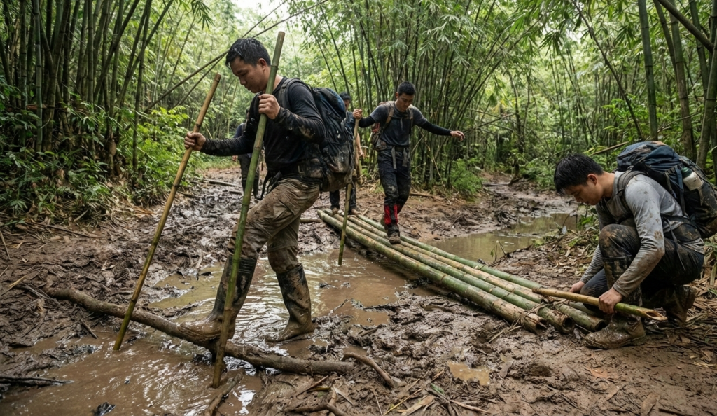
- Step on bamboo roots whenever possible (they’re solid)
- Use trekking poles to test depth before committing
- Side-step along the trail edges where bamboo grows (firmer ground)
- In deep sections, keep moving – standing still = sinking
- Accept you’re getting muddy (mental game-changer)
The bamboo itself creates the second challenge.
Stalks grow so thick you can’t see more than 3-5 metres ahead.
The “trail” is often just a slightly clearer section between bamboo walls.
Your armed KWS ranger (recommended for safety) knows the way.
Follow them. Don’t freelance.
Buffalo use these same paths.
Fresh dung everywhere.
That’s why having a ranger with a rifle is a smart call.
Wildlife encounters in the bamboo:
- Buffalo: Most common, most dangerous, give them space
- Elephants: Less common but they’re here (hence the name)
- Leopards: Rarely seen, but present
- Colobus monkeys: Constantly chattering in the canopy
- Forest birds: Over 50 species in this zone alone
The bamboo zone is where most people’s legs start screaming.
Constant up.
Zero flat sections.
Every step requires lifting your foot out of mud.
It’s like doing weighted squats for 3 hours straight.
Reaching the Summit: 3,906m
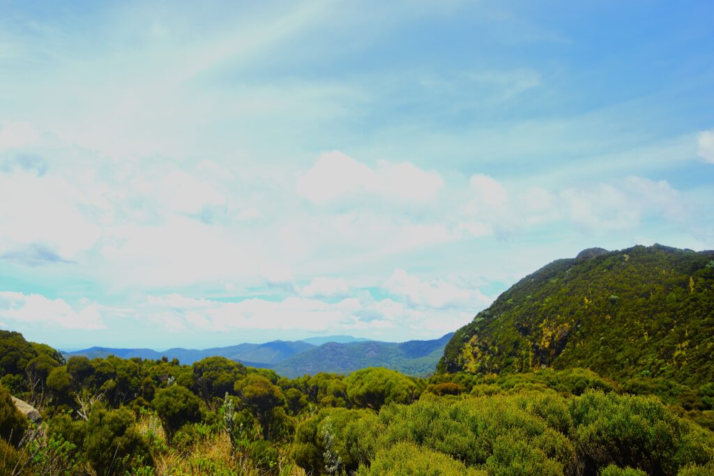
Around km 6-7, the bamboo starts thinning.
Heather takes over.
The trail gets rockier (less mud, finally).
But now the altitude hits you.
At 3,500m+, every breath feels like half a breath.
Summit push characteristics:
- Terrain: Rocky moorland, tussock grass, volcanic boulders
- Weather exposure: No tree cover, wind picks up dramatically
- Temperature: Can drop 15°C in minutes
- Visibility: Often foggy/cloudy (summit views are lottery)
- Mental game: This is where people quit (don’t be that person)
The final kilometre is deceptive.
You can see the summit.
It looks close.
It’s not.
The thin air makes everything take twice as long.
Your legs are cooked from the bamboo section.
And now you’re climbing over volcanic rocks at nearly 4,000m.
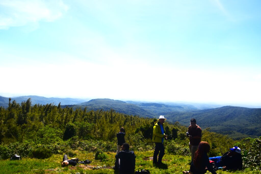
What you see at the summit (if weather cooperates):
- Mount Kenya looming to the east
- The entire Aberdare moorland plateau
- Rift Valley escarpment to the west
- Other Aberdare peaks (Satima, Kinangop, Dragon’s Teeth)
- Lake Naivasha shimmering in the distance
But here’s the truth: 60% of summits are in cloud.
You might get 10 minutes of clear views.
Or zero.
That’s high-altitude hiking.
The summit itself is anticlimactic – a rocky high point with a cairn.
No dramatic peak.
Just the satisfaction of getting there.
Descent reality check:
Going down is harder than going up.
Your quads are already destroyed.
Now you’re descending 1,300m through the same mud zones.
Except gravity is working against you.
Slips are constant.
Twisted ankles are common.
Trekking poles become mandatory, not optional.
Budget 4-5 hours for the descent (almost as long as the ascent).
Essential Gear for High-Altitude Moorlands
Let’s talk gear.
Because the wrong setup on Elephant Hill can turn an epic day into a survival situation.
The non-negotiables:
Footwear:
- Waterproof hiking boots (ankle support mandatory)
- Gaiters (keep mud out of boots)
- Extra socks (your feet will get wet, change at summit)
Clothing layers:
- Moisture-wicking base layer
- Insulating mid-layer (fleece or down)
- Waterproof shell jacket
- Waterproof pants (not rain pants – proper mud-proof trousers)
- Warm hat and gloves (summit is cold)
- Buff or neck gaiter (wind protection)
Equipment:
- Trekking poles (dual poles, not optional)
- 2-3L water (or purification tablets)
- Headlamp (in case you’re slower than expected)
- High-energy snacks (nuts, dried fruit, energy bars)
- First aid kit (blister kit essential)
- Whistle (emergency signal)
- Fully charged phone (offline maps downloaded)
What NOT to bring:
- Cotton anything (stays wet, hypothermia risk)
- New boots (break them in first)
- Too much camera gear (protect what you bring)
- Attitude (check it at the trailhead)
Fitness preparation:
Don’t show up unprepared.
Minimum prep (4-6 weeks before):
- 2-3 hikes per week with elevation gain
- Stair climbing with weighted pack
- Leg strength training (squats, lunges)
- Cardiovascular endurance work
- Practice hiking in mud (if possible)
Altitude acclimatisation:
Sleep at 2,500m+ the night before if possible.
Or do a shorter Aberdare hike (Karuru Falls, Kinangop) a few days prior.
Your body needs time to adjust.
Logistics you need sorted:
Park entry (2026 fees):
- East African citizens: KES 800 (adults)
- Residents: KES 1,100 (adults)
- Non-residents: USD 70 (adults)
Access: Via Njambini Forest Gate, 4×4 required
Ranger: Armed KWS ranger recommended (arranged at gate or through tour operator)
Start time: 6:00-7:00am (you want full daylight)
Group size: Minimum 2 people, ideally 4-6
At Daring Escapes, we handle all the logistics.
Park fees, ranger coordination, transport, gear checks.
Because the last thing you need is admin stress before a 10-hour hike.
Weather windows:
Best months: June-September (dry season, less mud)
Acceptable: December-February (cooler but doable)
Rainy seasons: March-May, October-November are doable but require checking weather conditions closely, as we always do at Daring Escapes for optimal experience
Even in dry season, expect some mud.
This is the Aberdares.
Mud is permanent.
Safety protocols:
- Tell someone your plan (gate times, expected return)
- Stick with your group and ranger
- Turn back if weather deteriorates (summit isn’t worth it)
- Watch for altitude sickness symptoms (headache, nausea, dizziness)
- Carry emergency contact: KWS hotline 0800 597 000
Common mistakes we see:
- Underestimating the mud (wear crap boots, suffer accordingly)
- Not bringing enough water (dehydration at altitude is brutal)
- Poor pacing (going too fast early, bonking at km 6)
- Ignoring altitude symptoms (pride before the fall)
- Wrong clothing (cotton kills, literally)
Why Elephant Hill Deserves Your Respect
Look, I’m not trying to scare you off.
The Elephant Hill trek is absolutely doable for fit hikers with proper preparation.
We’ve guided everyone from 20-year-olds to 60-year-olds up this mountain.
But it demands respect.
This isn’t a casual day hike.
It’s a serious undertaking in remote wilderness.
What you get for your effort:
✓ Bragging rights (legitimately earned)
✓ Spectacular high-altitude moorland ecosystem
✓ Wildlife encounters most people never experience
✓ Physical and mental challenge that builds character
✓ Understanding of why the Aberdare Range is special
The people who summit Elephant Hill join a small club.
Most tourists never even hear about this trail.
The ones who attempt it? About 30% turn back.
The ones who summit? They remember it forever.
If you’re serious about tackling this beast, do it right.
Train properly.
Get the right gear.
Go with people who know the mountain.
Daring Escapes has been guiding Elephant Hill for years.
We know every mud zone, every tricky section, every weather pattern.
More importantly, we know when to push forward and when to turn back.
The mountain will still be there tomorrow.
FAQs About Elephant Hill Trek
How long does the Elephant Hill hike take?
8-10 hours round trip for most hikers. 4-5 hours ascent, 4-5 hours descent. Faster hikers can do it in 7 hours, slower groups take 11-12 hours. Start early (6-7am) to ensure you’re down before dark.
Do I need a guide for Elephant Hill?
An armed KWS ranger is recommended for wildlife safety (buffalo, elephants are common). Beyond that, a guide isn’t legally required but highly recommended. The trail is poorly marked, weather changes fast, and navigation is tricky. Most people book with tour operators who provide guides, logistics, and safety support.
What fitness level is required?
You should be able to hike 15km+ with 1,000m elevation gain comfortably. Previous high-altitude hiking experience helps but isn’t essential. Prepare with 4-6 weeks of training (cardio, leg strength, endurance). If you can’t walk 10km on flat ground without stopping, you’re not ready.
Is Elephant Hill dangerous?
The main risks are wildlife (buffalo, elephants), altitude sickness, weather exposure, and injuries from slips/falls. The armed ranger handles wildlife encounters. Proper preparation minimizes other risks. Don’t attempt this alone or unprepared.
What’s the best time of year to hike Elephant Hill?
Dry season (June-September) offers the best conditions with less mud, better weather, and clearer views. December-February is also excellent but colder. Rainy seasons (March-May, October-November) are doable but require careful weather monitoring for optimal conditions, which we always do at Daring Escapes before any trek.