
Ragia Forest is one of the wildest and least explored corners of the Aberdares.
Hidden on the western edge of the range, its muddy jungle trails lead through bamboo forests, waterfalls, caves, and misty valleys few hikers in Kenya ever properly experience.
Where the Aberdares turn into a jungle
Ragia Forest sits on the western edge of the Aberdare Range, hidden inside one of the densest and least explored parts of the mountain.
While other areas of the Aberdares open into moorlands and wide viewpoints, Ragia feels far more enclosed. Wetter. Darker. Almost jungle-like in some sections.
The forest here grows thick quickly. Bamboo closes around the trails, rivers cut through deep vegetation, and mud becomes part of the hike almost immediately after rain.
Fog moves through the trees without warning, visibility changes constantly, and the whole landscape feels quieter than the better-known parts of the park.
Very few people come here compared to the main Aberdare routes.
Access is controlled through Kenya Forest Service entry fees, which are usually around KES 200–400 for citizens and residents, and roughly KES 600 for non-residents, plus a small local community fee.
Standard Aberdare National Park entry fees apply separately depending on the route and access gate used.
Because KWS rates can change over time, it is always worth checking the official website for the latest updated park fees before visiting.

Hikes into the deeper sections of Ragia Forest also require two armed rangers because of the wildlife moving through the forest.
Ranger fees are usually around KES 1,500 per ranger, meaning most groups should expect roughly KES 3,000 in total for ranger support during the hike.
That isolation is part of what makes Ragia Forest special. The trails feel rougher, less polished, and more exploratory, like the forest is still deciding whether it wants to let you through or not.
The trails that define Ragia Forest
Ragia Forest offers several interconnected trails moving through waterfalls, bamboo zones, caves, rivers, and steep forest terrain across the western Aberdares.
The main route is the Ragia Waterfall Trail, usually around 8–10 km depending on the section explored, and takes roughly 3 to 5 hours.
This is the most popular hike in the forest, leading through dense jungle paths, river crossings, slippery descents, and eventually toward the hidden waterfall deep inside the valley.
The Mau Mau Cave route is shorter, usually around 4–6 km, and focuses more on the historical caves hidden inside the forest where freedom fighters once sheltered during Kenya’s independence struggle.
Further uphill, the bamboo ridge trails extend toward quieter sections of the mountain with hidden viewpoints overlooking the Aberdare valleys.
These routes can vary between 6 and 12 km depending on the chosen loop and become much muddier and steeper after rain.
None of the trails feel overly developed. Roots, wet rock, river crossings, and shifting weather slow the pace constantly, which is part of what makes Ragia feel more like exploration than a typical hike.
And among all the routes hidden inside the forest, the waterfall trail remains the one most people remember longest.
Into the valley: Ragia’s waterfall trail
The Ragia Waterfall Trail is the route that defines the Ragia Forest best.
Around 8 to 10 kilometres long depending on the section explored, it usually takes between 3 and 5 hours, although weather and mud can slow the hike down quickly.
The trail starts deceptively calmly before the forest closes around you almost completely.
Bamboo leans over the path, roots twist across the ground, and the air starts feeling colder and heavier as you descend deeper into the valley.
Some sections turn muddy within minutes after rain, while others force you through slippery rock descents and shallow river crossings where balance suddenly matters a lot more than expected.
This is not a polished hiking trail.
At times, the route feels more like moving through untouched jungle than walking inside a managed forest. You hear water long before you see it.
Birds echo somewhere high above the canopy, fog shifts constantly between the trees, and every corner feels slightly hidden from the last.
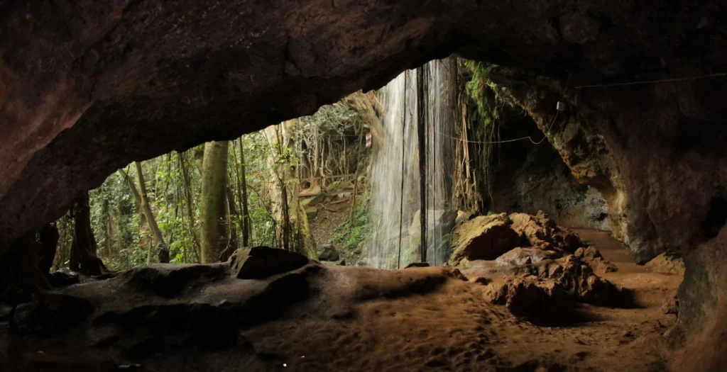
The final approach to the waterfall is the part most people remember.
The sound grows louder first. Then the forest suddenly opens into a cold misty clearing where Ragia Falls crashes down through thick vegetation and dark volcanic rock.
Ferns cover the edges of the pool below, vines hang from the surrounding cliffs, and the entire place feels strangely isolated from the rest of the mountain.
There are no fences, platforms, or crowds waiting at the bottom.
Just the waterfall, the forest, and the feeling that you found something most people never reach.
Kenya’s hidden resistance history: deep inside the Mau Mau caves
Somewhere deeper inside Ragia Forest, the trails stop feeling purely scenic and start carrying the weight of history too.
The route toward the Mau Mau caves branches away from the main waterfall sections and moves through darker, quieter forest where the vegetation thickens and the atmosphere changes completely.
The hike itself is not especially long, usually around 4 to 6 kilometres depending on the route taken, but the terrain stays uneven, muddy, and enclosed beneath thick canopy almost the entire way.
Eventually, the forest opens around large volcanic rock formations hidden between the trees.
These caves once served as shelters for Mau Mau fighters during Kenya’s struggle for independence.
Deep inside the forest, far from roads and visibility, they became hiding places, supply points, and temporary refuges during some of the country’s most difficult years.
And standing there today still feels heavy somehow.
The caves are cold, damp, and marked by decades of moisture and erosion.
Light barely reaches some sections properly, while roots and moss slowly reclaim parts of the rock itself.
Unlike more visited historical landmarks around Kenya, nothing here feels overly restored or staged.
The forest simply kept growing around the history.
That isolation gives the place its atmosphere. You hear water somewhere deeper in the valley, wind moving through bamboo above the caves, and almost nothing else.
Ragia Forest reminds you constantly that the Aberdares were never only about landscapes. They were also places of survival.
Where the forest finally opens
Beyond the Mau Mau caves, several trails continue climbing toward the upper bamboo ridges overlooking the western Aberdares.
his is where the forest slowly starts opening and the landscape changes again.
The first ridge viewpoints usually appear around 1.5 to 2 hours into the hike from Ragia Forest Station near Sasumua Dam (approx. coordinates: -0.7957, 36.6813), although weather and mud can slow the pace down significantly.
One of the best known lookouts sits along the upper ridge sections facing Elephant Hill and the Kinangop valleys (approx. coordinates: -0.7825, 36.6698).
On clear mornings, the forest suddenly breaks apart into huge open views stretching across the western side of the Aberdare Range before clouds roll back through the valleys again.
Further along the ridge, smaller unmarked viewpoints appear quietly between the bamboo corridors.
Some overlook deep gorges hidden beneath the canopy, while others reveal waterfalls cutting through the forest far below long before you actually reach them.
This section of Ragia feels calmer than the lower waterfall routes, but not easier.
The terrain stays rough almost the entire way.
Thick mud, exposed roots, slippery descents, and narrow bamboo sections constantly slow the hike down, especially after rain.
In several places, elephant paths cross directly through the trails, reminding you how wild and active this forest still is.
That contrast is what makes Ragia Forest memorable.
One moment the forest feels completely closed around you. The next, the bamboo opens and the entire western Aberdare landscape suddenly appears beneath the clouds.